
| ___LINK_OPEN_ href="http://2.bp.blogspot.com/_v1QXJ8RY4AE/THcfDNrIP6I/AAAAAAAAJto/-S94qqGBwzg/s1600/seringapatam+coral+reef+map+location.jpg"___ |
| ಆಸ್ಟ್ರೇಲಿಯ ದಿಂದ ಪಶ್ಚಿಮಕ್ಕೆ ಹಿಂದೂ ಸಾಗರದಲ್ಲಿ ನೆಲೆಗೊಂಡ seringapattam ದ್ವೀಪ [ಕನ್ನಡಿಗರ ಹೆಮ್ಮೆ] |
___LINK_OPEN_ href="http://4.bp.blogspot.com/_v1QXJ8RY4AE/THce0MG-SYI/AAAAAAAAJtY/K0Y4PcTT90g/s1600/300px-Scott_and_Seringapatam-ReefBase_highres_STS080_STS080-.jpg"___ |
| ಈ ಕನ್ನಡ ನಾಡಿನ ಕೀರ್ತಿಪತಾಕೆ ಹಿಂದೂ ಮಹಾ ಸಾಗರದಲ್ಲಿ ನೆಲೆಸಿರುವುದು ಹೀಗೆ. |
ನಮಸ್ಕಾರ ಬನ್ನಿ ಈ ಸಂಚಿಕೆಯಲ್ಲಿ ನಿಮಗೆ ಒಂದು ಆಶ್ಚರ್ಯಕರ ವಿಚಾರ ತಿಳಿಸಿಕೊಡುತ್ತೇನೆ. ನಮಗೆಲ್ಲಾ ಗೊತ್ತು ಕರ್ನಾಟಕದ ಮಂಡ್ಯ ಜಿಲ್ಲೆಯ ಒಂದು ಸಣ್ಣ ತಾಲೂಕು ಶ್ರೀರಂಗಪಟ್ಟಣ ಇತಿಹಾಸ ಪ್ರಸಿದ್ದ ಅಂತ.ಈ ಊರನ್ನು ಹಿಂದೆ ಆಂಗ್ಲರು serigapattam ಅಂತಾನು ಕರೀತಿದ್ರು.ಈಗ ನೋಡಿ ಆಸ್ಟ್ರೇಲಿಯ ದೇಶದ ಪಶ್ಚಿಮ ದಿಕ್ಕಿಗೆ ಸಮೀಪ ಒಂದು ಕೊರಾಲ್ ದ್ವೀಪಕ್ಕೆ seringapattam ಅಂತಾ ಹೆಸರಿಟ್ಟು ಕನ್ನಡ ನಾಡಿನ ಈ ಊರಿನ ಹೆಸರು ಮೆರೆಯುವಂತೆ ಮಾಡಲಾಗಿದೆ. ಅಂತರ್ಜಾಲ ಜಾಲಾಡಿದಾಗ ಈ ಹಿಂದೆ ಟಿಪ್ಪೂ ಸುಲ್ತಾನ್ ಕಾಲದಲ್ಲಿ ನಡೆದ ಮೈಸೂರಿನ ಅಂತಿಮ ಯುದ್ದ [೧೭೯೯] ದಲ್ಲಿ ಭಾಗವಹಿಸಿ ನಂತರ ಆಸ್ತ್ರೆಲಿಯಗೆ ತೆರಳಿದ ಸ್ಕಾಟ್ ಕುಟುಂಬ ಒಂದು ಈ ದ್ವೀಪವನ್ನು ಖರೀದಿಸಿಶ್ರೀ ರಂಗ ಪಟ್ಟಣದಲ್ಲಿ ನಡೆದ ಅಂತಿಮ ಕಾಳಗದ ನೆನಪಾಗಿ ಆ ದ್ವೀಪಕ್ಕೆ seringapattam ಅಂತಾ ಹೆಸರನ್ನು ನಾಮಕರಣ ಮಾಡಿ,ಸಂಭ್ರಮಿಸಿದೆ.ಬಹುಷಃ ಈ ದೇಶದ ಯಾವುದೇ ಊರಿನ /ಪಟ್ಟಣದ ಬಗ್ಗೆ ಇಂಥಹ ಘಟನೆ ಇರುವುದಿಲ್ಲ .ಬನ್ನಿ ಇದರ ಬಗ್ಗೆ ಕೆಲವು ಚಿತ್ರಗಳನ್ನು ಅಂತರ್ಜಾಲ ಕೃಪೆ ಇಂದ ನಿಮಗಾಗಿ ಕೆಲವು ಚಿತ್ರಗಳನ್ನು ಡೌನ್ ಲೋಡ್ ಮಾಡಿದ್ದೇನೆ ನೋಡಿಬಿಡೋಣ ಬನ್ನಿ
___LINK_OPEN_ href="http://1.bp.blogspot.com/_v1QXJ8RY4AE/THcfGwNI8tI/AAAAAAAAJtw/I__h4fEPg0o/s1600/seringapatam+coral+reef+map+location.jpg+sat+image.jpg"___ |
| ಉಪಗ್ರಹ ಚಿತ್ರ ದಲ್ಲಿ ಸೇರಿಂಗ ಪಟ್ಟಂ [ಶ್ರೀ ರಂಗ ಪಟ್ಟಣ ]ದ್ವೀಪ ಕಾಣುವುದು ಹೀಗೆ!! |
___LINK_OPEN_ href="http://2.bp.blogspot.com/_v1QXJ8RY4AE/THcfMhzyfOI/AAAAAAAAJt4/n62MM9OGg2s/s1600/seringapatam+coral+reef+photo.JPG"___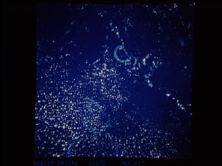 |
| ದ್ವೀಪದ ಮತ್ತೊಂದು ಸುಂದರ ನೋಟ . |
Scott and Seringapatam Reefs is a group of
atoll-like reefs in the
___LINK_OPEN_title="Timor Sea" href="http://medlibrary.org/medwiki/Timor_Sea"___Timor Sea more than 300 km northwest of
___LINK_OPEN_title="Cape Leveque" href="http://medlibrary.org/medwiki/Cape_Leveque"___Cape Leveque,
___LINK_OPEN_title="Western Australia" href="http://medlibrary.org/medwiki/Western_Australia"___Western Australia, on the edge of the
___LINK_OPEN_title="Continental shelf" href="http://medlibrary.org/medwiki/Continental_shelf"___continental shelf. There are three or four separate reef structures, depending on whether Scott Reef Central is counted separately. The group is just one of a number of reef formations off the northwest coast of
Australia and belongs to
___LINK_OPEN_title="Western Australia" href="http://medlibrary.org/medwiki/Western_Australia"___Western Australia. Further to the northeast are
___LINK_OPEN_title="Ashmore and Cartier Islands" href="http://medlibrary.org/medwiki/Ashmore_and_Cartier_Islands"___Ashmore and Cartier Islands, and to the southwest are the
___LINK_OPEN_title="Rowley Shoals" href="http://medlibrary.org/medwiki/Rowley_Shoals"___Rowley Shoals......................................................
Each of the three reefs rises steeply from the
seabed 400 to 500 m below. Much of the reaf area dries at low tide, but besides Sandy Islet of Scott Reef South, there are only a few rocks and
sandbanks above the high water mark.
- Scott Reef South (also Horseshoe Reef or South Reef) is a large crescent-shaped formation that has a rare and unusual double reef crest. Its lagoon, has depths of over 24 m throughout the greater portion. The reef with its lagoon covers an area of 144 km².
- Scott Reef Central, because of its proximity occasionally subsumed within Scott Reef South, lies off West Hook (the western extremity of the crescent of Scott Reef South), with Sandy Islet at ___LINK_OPEN_rel="nofollow" href="http://toolserver.org/%7Egeohack/geohack.php?pagename=Scott_and_Seringapatam_Reefs¶ms=14_03_S_121_46_E_"___14°03′S 121°46′E / 14.05°S 121.767°E (690 meters north-south, up to 110 meters wide, with an area of 0.05 km²). This reef falls dry to the extent of 0.8 to 1.6 km from the islet. There is a conspicuous tower on the islet and also a boulder with a height 2.4 m near its northern end. A detached reef, which dries 0.6 m, lies 2.4 km northeast of Sandy Islet. The passage between Scott Reef South and Scott Reef Central is only 33 m deep, much less than the passages between the other reefs (366 m between Scott Reef South and Scott Reef North).
- Scott Reef North consists of a large, approximately circular-shaped, reef lying 23 km southwest of Seringapatam Reef. The reef is composed of a narrow reef-crest that is backed by broad reef flats — much of which becomes exposed at low tide — and a deep central lagoon that is connected to the open sea by two delta-like channels. The reef with its lagoon covers an area of 106 km².
___LINK_OPEN_ href="http://4.bp.blogspot.com/_v1QXJ8RY4AE/THce0MG-SYI/AAAAAAAAJtY/K0Y4PcTT90g/s1600/300px-Scott_and_Seringapatam-ReefBase_highres_STS080_STS080-.jpg"___
- Seringapatam Reef is located at ___LINK_OPEN_rel="nofollow" href="http://toolserver.org/%7Egeohack/geohack.php?pagename=Scott_and_Seringapatam_Reefs¶ms=13_40_S_122_05_E_"___13°40′S 122°05′E / 13.667°S 122.083°E, 23 km north of Scott Reef North. This reef is named after the Battle of Seringapatam, the historical ___LINK_OPEN_title="Fourth Anglo-Mysore War" href="http://medlibrary.org/medwiki/Fourth_Anglo-Mysore_War"___last and decisive battle fought between ___LINK_OPEN_title="Tipu Sultan" href="http://medlibrary.org/medwiki/Tipu_Sultan"___Tipu Sultan and the ___LINK_OPEN_title="British Raj" href="http://medlibrary.org/medwiki/British_Raj"___British Raj forces in Southern India. It is a small circular-shaped reef. Its narrow reef rim encloses a relatively deep lagoon. Much of the reef becomes exposed at low tide. There are large boulders around its edges, with a few sandbanks, which rise about 1.8 m above the water, on the west side. Seringapatam Reef covers an area of 55 km² (including the central lagoon). ನೀವು ಈ ತಾಣಕ್ಕೆ ಹೋಗಿ ಕನ್ನಡ ನಾಡಿನ ಹೆಮ್ಮೆಯ ದ್ವೀಪ ಒಂದರ ಹೆಸರನ್ನು ದೂರದ ಆಸ್ಟ್ರೇಲಿಯ ಸಮೀಪ ಇಡಲಾಗಿರುವ ಸೋಜಿಗವನ್ನು ಅನುಭವಿಸಿ.ಬನ್ನಿ ಹೇಳೋಣ ನಮ್ಮ ದೇಶದ ಇತಿಹಾಸಕ್ಕೆ ಜಯವಾಗಲಿ. ನೋಡಿದ್ರಾ ನಮ್ಮ ದೇಶದ ಇತಿಹಾಸ ಎಂಥಹ ವಿಶೇಷ ಹೊಂದಿದೆ.ಆಲ್ವಾ ನೀವೇನಂತೀರಾ!!!











ಪ್ರತಿಕ್ರಿಯೆ (2)